Reading HRM’s Online Zoning Map: A Step‑by‑Step Guide for First‑Time Developers
Halifax Regional Municipality (HRM) offers ExploreHRM, an online zoning map that helps developers understand land use regulations and property details. This tool is essential for navigating zoning rules, which dictate what, where, and how you can build. Here's what you need to know:
- Why it matters: Zoning impacts everything from project costs to timelines. Missteps can cause delays, fines, or legal issues.
- Key features: Search by address, view zoning classifications, and download data for detailed analysis.
- Recent updates: New rules allow higher-density housing in urban and residential zones, creating opportunities for multi-unit developments.
- Getting started: Use ExploreHRM to check zoning codes, overlays, and development limits before planning your project.
Whether you're a first-time developer or experienced in the field, this guide breaks down how to use ExploreHRM effectively and avoid common pitfalls.
How To Read A Zoning Map? - CountyOffice.org
How to Access and Use the ExploreHRM Online Zoning Map
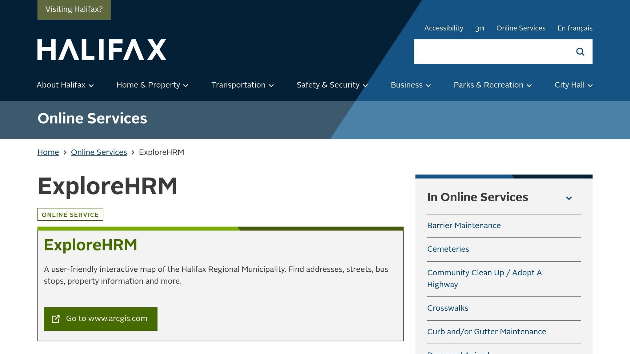
If you're diving into Halifax zoning details for your next multi-unit project, ExploreHRM is your go-to tool. This platform provides quick and easy access to zoning data, helping you make informed decisions with precision.
Opening the ExploreHRM Tool
To get started, head to www.arcgis.com using your web browser [6]. Once the map loads, you'll see Halifax displayed with multiple data layers. You can search by entering a full address, a partial street name, or even just a community name (like "Quinpool Road"). The tool will instantly zoom in on the location and outline the relevant property boundaries.
When you click on a property, a detailed information panel pops up. This panel includes the property's zoning classification, permitted uses, and any restrictions you need to be aware of - essential details for planning your project.
Map Navigation Tools You Need to Know
The map's navigation tools make it user-friendly and practical. Use the zoom controls to switch between detailed and broader views. You can also toggle layers to display property boundaries, zoning classifications, or transit routes, depending on what you need to see.
For precise measurements, the tool includes options to calculate distances (in metres) and areas (in hectares or square metres). This is especially helpful for verifying setbacks or estimating building footprints. The legend feature helps you decode the map's colour coding and symbols, so you can quickly identify residential, commercial, and mixed-use zones. Once you've navigated to the information you need, you can download it for further analysis or sharing.
How to Download and Save Zoning Information
For a deeper dive into zoning data, visit the Open Data Catalogue, where you can download detailed datasets and printable maps [1]. The catalogue organizes everything by data type, making it easy to find zoning information, property boundaries, or specific regulations. If you're looking for advanced features or guidance, the ExploreHRM User Guide is a helpful resource.
Downloaded files are compatible with other planning tools and can be shared electronically with your team. This ensures everyone has access to the latest zoning information, keeping your project aligned and on track.
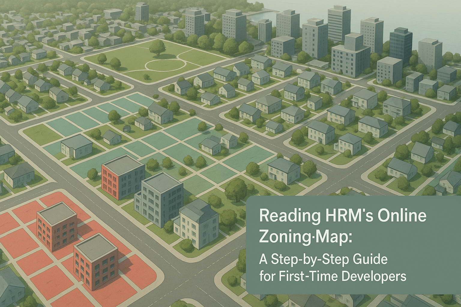
How to Read Zoning Classifications and Map Legends
Once you've started exploring the HRM map, the next step is understanding its zoning codes and map legends. This will help you determine if your project aligns with local development rules.
Reading Zoning Codes and Map Colours
HRM zoning codes, such as R-2, MU, or ER-3, are marked with different colours on the ExploreHRM map. These codes outline what kinds of developments are allowed and any restrictions that might apply to your project.
Recent updates have made it easier to develop multi-unit housing. In areas with existing city water and wastewater services, all residential zones now permit at least four units per property. Many former single-family zones have been updated - ER-2 (Established Residential 2) zones now replace older ER-1 areas to allow higher density, while ER-3 zones provide even more flexibility for multi-unit developments [4].
For mixed-use projects, look for zones marked MU. These zones allow both residential and commercial uses, giving you a broader range of development possibilities.
Once you understand the zoning codes and their associated colours, the next step is to dive into the corresponding Land Use By-Laws to get a complete picture of the rules and requirements.
Finding and Reading Land Use By-Laws
After identifying a property's zoning code, you'll need to review the specific regulations tied to it. HRM's online Land Development Regulations provide detailed information about what each zoning code permits.
These regulations, managed by HRM's planning department [7][8], are available online, making it easy to cross-reference zoning details from the map with the written rules. This ensures you have all the information you need to make informed decisions about your project. Pay close attention to sections covering permitted uses, building heights, lot coverage, and parking requirements, as these factors can have a big impact on your project's design and budget.
Additionally, don't overlook overlay zones, which might impose extra restrictions on your property.
Identifying Overlays and Special Restrictions
Beyond standard zoning classifications, some properties fall under overlay zones. These zones add another layer of rules, regardless of the base zoning [9]. Overlay zones are clearly marked on the ExploreHRM map, with examples including Floodplain Management, Hillside Development, Wildland-Urban Interface, and Geologic Hazard Overlays [9].
If your property is in an overlay zone, you’ll need to meet additional requirements. These could include stricter rules on land use, building sizes, or construction methods, which might lead to higher costs or longer approval times. Identifying these zones early can save you from unexpected challenges later.
For properties in overlay zones, you may need to submit extra documentation, like geotechnical assessments, before starting construction [9]. To confirm whether overlays or special restrictions apply to your property, check the Zoning By-Law Maps on ExploreHRM or contact HRM's Planning Department for guidance [10].
sbb-itb-16b8a48
How to Evaluate Development Potential for Multi-Unit Rental Projects
Once you’ve got a handle on zoning, the next step is figuring out your property’s potential for multi-unit development. This involves digging into zoning rules, crunching numbers to calculate unit potential, and steering clear of common mistakes that could derail your project.
Zoning Requirements for Multi-Unit Properties
In Halifax Regional Municipality (HRM), R-2 zoning is tailored for multi-family use, making it a go-to option for multi-unit rental developments [12]. This zoning differs from R-1, which is strictly for single-family homes [12]. Before making any plans, get written confirmation of your property’s zoning from HRM.
Several zoning factors can shape your project’s potential. These include building height restrictions, minimum lot sizes, and density limits, which define how many housing units you can put on a piece of land [11]. Parking and greenspace requirements also eat into the buildable area, so they’re worth keeping in mind. If you’re considering mixed-use zoning, know that combining residential and commercial spaces often brings extra challenges, like juggling different parking needs and accommodating added infrastructure demands [13].
How to Calculate Development Potential
Start by measuring your property’s exact dimensions. Then, check the Land Use By-Laws to find your zone’s density limit, usually listed as units per hectare or acre [11]. Multiply your lot size by this density ratio to estimate the maximum number of units you might be able to build.
But it’s not just about density. You’ll need to factor in setbacks, lot coverage limits, and requirements for parking and greenspaces. Building height restrictions also come into play - adding extra storeys can increase your unit count, but only if it fits within the density and zoning rules.
Once you’ve done the math, compare your findings with local market trends. Does the potential unit count align with what the market demands? Also, consider construction costs. Just because zoning allows for a certain number of units doesn’t mean it’ll be financially feasible to build them all.
Common Zoning Analysis Mistakes to Avoid
Mistakes in zoning analysis can be costly, especially for new developers. One common error is misinterpreting density limits. Remember, density limits are just that - limits. They don’t guarantee that you can build to the maximum allowance. Setbacks, parking, and greenspace requirements often reduce the actual buildable area, so always work from the realistic buildable area, not the theoretical maximum.
Another pitfall is failing to keep up with zoning by-law changes. HRM’s zoning regulations can shift, and as of October 3, 2025, the Minister of Municipal Affairs designated HRM as an interim planning area. This means the Minimum Planning Requirements Regulations now apply, potentially impacting development feasibility [3]. Always double-check current rules through ExploreHRM or by contacting 311.
Parking requirements are another area where developers often stumble. In urban areas, underestimating parking needs can eat into profitability. Similarly, ignoring the specific rules of HRM’s twenty-one Community Plan Areas can lead to expensive mistakes. Each area has its own land use by-laws and policies [3], so don’t rely on general assumptions about HRM-wide rules.
Lastly, rezoning or obtaining special permits isn’t a quick or guaranteed solution. If your property isn’t already zoned for multi-unit use, the rezoning process can be lengthy and uncertain [11]. Community opposition over concerns like traffic or noise can further delay approvals. Be sure to account for these risks when planning your timeline and budget.
To avoid these missteps, double-check all your metrics on ExploreHRM and ensure your plans are based on the most up-to-date information. It’s the best way to set your project up for success.
Practical Tips for First-Time Developers Using HRM's Zoning Map
Navigating HRM's zoning map can feel overwhelming, but with a methodical approach and timely advice, you can confidently connect your zoning research to actionable construction plans. Here’s how to get started.
Zoning Research Checklist
Understanding zoning classifications is just the beginning. To refine your project plans, follow this research checklist to avoid costly mistakes.
Start by using ExploreHRM [1][5]. Enter your civic address or Property Identification Number (PID) to access detailed property information. This will help you identify your zoning code, such as R-2 for residential or C-1 for commercial properties [2].
After identifying your zone, check the permitted and conditional uses for that classification [2]. Then, dive into the development standards that apply to your project: building height limits, lot coverage maximums, required setbacks, and floor area ratios [2].
Don’t overlook overlay districts - these can add extra layers of regulation. For instance, historic preservation zones, floodplain overlays, or protected areas may affect your plans. The ExploreHRM User Guide can provide further assistance [1][2].
Make sure the zoning supports your intended use. Look for any upcoming regulatory changes, identify restrictions, determine permit requirements, and consider the community impact of your project [7].
Finally, save your research by downloading data from the Open Data Catalogue [1]. Keeping detailed records will be invaluable when consulting with contractors or planning staff.
When to Contact HRM Planning Staff
To avoid unnecessary delays, know when to reach out to HRM Planning staff. They’re your go-to resource for planning or subdivision applications, including rezoning, variances, and site-plan approvals [14]. They can also guide you on specialized issues like telecommunications, heritage concerns, or zoning confirmation letters [14].
If your plans don’t align with current zoning bylaws, you’ll need to initiate a rezoning or amendment application [16]. Municipal planning officials can clarify regulations and help you navigate the process [16].
For in-person assistance, visit the Planning & Development Permit Office at 5251 Duke St, 3rd Floor, Suite 300, Duke Tower, Halifax. Office hours are 8:30 a.m. to 4:30 p.m., Monday to Friday, excluding holidays [14][17].
Engage early in the planning process. Waiting until permits are issued or significant resources are spent can lead to complications. Early consultations ensure you’re aware of zoning constraints before committing too much time or money [15].
Connecting Zoning Analysis with Construction Planning
Zoning research isn’t just a checkbox - it should shape every aspect of your construction planning. From the outset, align your zoning compliance with your project’s budget and timeline. If your research shows you’ll need variances or special permits, plan for the additional time and costs. These processes can extend your schedule by months and add significant expenses.
Zoning constraints directly impact construction decisions. For example, height restrictions might limit you to three storeys, which affects foundation design and mechanical systems. Similarly, setback requirements dictate your building’s footprint and could influence whether you opt for stick-frame construction or another method.
Work with builders who incorporate zoning requirements into the design phase. This integrated approach ensures your construction team considers zoning rules from the start, preventing expensive redesigns if initial plans don’t comply with regulations.
Zoning also affects financial feasibility. If density limits reduce the number of units you can build, your revenue projections will need adjusting, which may require rethinking your budget. Use your zoning analysis to set realistic expectations with your team about what’s achievable within HRM’s regulations.
Key Takeaways for First-Time Developers
Making Smart Decisions with the HRM Zoning Map
Understanding the HRM zoning map is an essential starting point for your development project. Using the ExploreHRM tool, you can identify both opportunities and potential challenges early in the process. This helps you assess your project's feasibility and avoid unexpected expenses or delays.
The insights you gain from this research guide your decisions throughout the design and construction phases. By laying this groundwork, you're setting yourself up for smoother and more informed steps as you move forward in your development journey.
Your Next Steps for Development Success
Once you've completed your zoning research, it's time to turn your findings into actionable plans. Start by thoroughly analysing your specific property. Use a checklist to organize your research and document the key points.
For more complex issues, reach out to local planning staff. As Park Lake Development emphasized in their September 2025 analysis:
"Zoning interpretation can vary, so establishing open communication with local planning staff is invaluable for confirming assumptions before you move forward." [2]
Engaging with planning staff early can help clarify any uncertainties and ensure your project stays on track. Be prepared to address additional permits, variances, or rezoning requirements, as these can significantly impact your timeline and budget.
You may also want to consider working with local experts. Development firms familiar with HRM processes can provide valuable guidance, helping you understand not only what is permitted but also what is practical given the area's specific conditions and approval procedures [2].
Your research is complete when you can confidently answer these critical questions: What can you build? Where can you build it? What approvals are necessary? How will constraints affect your timeline and costs? With these answers in hand, you're ready to move forward with detailed design and construction planning.
FAQs
How do I check if my property is in an overlay zone and what does that mean for development?
If you want to find out whether your property falls within an overlay zone, head over to HRM's online zoning map. Just type in your property’s address or pinpoint its location on the map. Overlay zones come with extra rules or requirements - like design standards, heritage protections, or environmental factors - that could influence your development plans.
Taking a close look at the zoning map and its associated details will give you a clearer picture of the regulations tied to your property. This way, you can ensure your project aligns with local guidelines right from the start.
What can I do if my development plans don’t meet Halifax’s zoning by-laws?
If your development plans don't align with Halifax's zoning by-laws, there are a couple of routes you can take. One option is to apply for a zoning variance, which permits minor deviations from the existing regulations. Alternatively, you could request to rezone your property, which involves changing its zoning classification to better accommodate your project.
Both processes need approval from the Halifax Regional Municipality (HRM) and might include public consultations. To navigate these steps smoothly, it's wise to connect with a planning professional or reach out to the HRM planning department for guidance on the requirements and procedures.
How can I use ExploreHRM to evaluate the development potential of a property for a multi-unit rental project?
ExploreHRM is a straightforward tool designed to help you figure out the zoning and permitted uses for a specific property. All you need to do is enter the address, street name, or community into the search bar to pinpoint the land use zone.
After locating the zone, you can dive into the zoning classification to see what types of multi-unit rental developments are permitted, along with any restrictions. This insight gives you a better understanding of the property's potential, making it easier to plan your project with certainty.